Satellite Imagery API
The Satellite Imagery API is a 2-step API to get imagery data for your polygon. How it works:
-
Step 1. Search for satellite imagery and get metadata for a polygon.
You make a search API call to check available satellite imageries for your polygon. In the result, you get metadata and a list of API calls (as URLs) for available products (True Color, False Color, NDVI, EVI, EVI2, NRI, DSWI, and NDWI).
-
Step 2. Get imageries and zonal statistics.
As a result of Step 1, you have a response that contains metadata and a list of API calls for 4 groups of products: "image", "tile", "stats", and "data".
Using API call to a particular group, you can get:
- an image of a polygon in PNG format
- a tile in PNG format
- zonal statistics for NDVI, EVI, EVI2, NRI, DSWI, and NDWI indices of a polygon
- an image in GeoTIFF format.
Step 1. Search satellite images for a polygon
On this initial step we search all available satellite imageries for your polygon and return you URLs to them. URLs are organized in 4 groups — 'image', 'tile', 'stats' and 'data'. Use URLs from these 4 groups in the Step 2 to get images or metadata that you can embed to your application. Now you can get an image of your polygon in PNG, a tile in PNG format, metadata of NDVI, EVI, EVI2, NRI, DSWI and NDWI indices of polygon and the image in Tiff format.
Example of API Call:
http://api.agromonitoring.com/agro/1.0/image/search?start={start date}&end={end date}&polyid={ID of polygon}&appid={API key}
Parameters of request:
Necessary parameters:
appid
polygon_id
startStart date of the data search (unix time, UTC), e.g. start=1483218000
endEnd date of the data search (unix time, UTC), e.g. end=2504213200
Please note: if you specify a short period of time (from the 'start' to 'end'), then you may not receive the data by your polygon. According to the documentation of Sentinel-2 periodicity of scanning depends on the latitude and vary from 3 to 5 days. For Landsat-8 periodicity is 16 days.
Optional parameters:
resolution_minpx/meters
resolution_maxName of data source Landsat-8 (l8), Sentinel-2 (s2)
coverage_max%
coverage_min%
clouds_max%
clouds_min%
Example of API request:
http://api.agromonitoring.com/agro/1.0/image/search?start=1500336000&end=1508976000&
polyid=5aaa8052cbbbb5000b73ff66&appid=bb0664ed43c153aa072c760594d775a7
Example of API response:
[
   {
    "dt": 1502323200,
    "type": "Landsat 8",
    "dc": 100,
    "cl": 1.84,
    "sun": {
      "elevation": 60.583,
      "azimuth": 132.928
    },
    "image": {
      "truecolor": "http://api.agromonitoring.com/image/1.0/000598ba200/
      5baccca22b26590008d4da78?appid=63b351d5237d3a4232fe96f45c49671a",
      "falsecolor": "http://api.agromonitoring.com/image/1.0/010598ba200/
      5baccca22b26590008d4da78?appid=63b351d5237d3a4232fe96f45c49671a",
      "ndvi": "http://api.agromonitoring.com/image/1.0/020598ba200/
      5baccca22b26590008d4da78?appid=63b351d5237d3a4232fe96f45c49671a",
      "evi": "http://api.agromonitoring.com/image/1.0/030598ba200/
      5baccca22b26590008d4da78?appid=63b351d5237d3a4232fe96f45c49671a",
      "evi2": "http://api.agromonitoring.com/image/1.0/040598ba200/
      5baccca22b26590008d4da78?appid=63b351d5237d3a4232fe96f45c49671a",
      "nri": "http://api.agromonitoring.com/image/1.0/050598ba200/
      5baccca22b26590008d4da78?appid=63b351d5237d3a4232fe96f45c49671a",
      "dswi": "http://api.agromonitoring.com/image/1.0/060598ba200/
      5baccca22b26590008d4da78?appid=63b351d5237d3a4232fe96f45c49671a",
      "ndwi": "http://api.agromonitoring.com/image/1.0/070598ba200/
      5baccca22b26590008d4da78?appid=63b351d5237d3a4232fe96f45c49671a"
    },
    "tile": {
      "truecolor": "http://api.agromonitoring.com/tile/1.0/{z}/{x}/{y}/
      000598ba200/5baccca22b26590008d4da78?appid=63b351d5237d3a4232fe96f45c49671a",
      "falsecolor": "http://api.agromonitoring.com/tile/1.0/{z}/{x}/{y}/
      010598ba200/5baccca22b26590008d4da78?appid=63b351d5237d3a4232fe96f45c49671a",
      "ndvi": "http://api.agromonitoring.com/tile/1.0/{z}/{x}/{y}/
      020598ba200/5baccca22b26590008d4da78?appid=63b351d5237d3a4232fe96f45c49671a",
      "evi": "http://api.agromonitoring.com/tile/1.0/{z}/{x}/{y}/
      030598ba200/5baccca22b26590008d4da78?appid=63b351d5237d3a4232fe96f45c49671a",
      "evi2": "http://api.agromonitoring.com/tile/1.0/{z}/{x}/{y}/
      040598ba200/5baccca22b26590008d4da78?appid=63b351d5237d3a4232fe96f45c49671a",
      "nri": "http://api.agromonitoring.com/tile/1.0/{z}/{x}/{y}/
      050598ba200/5baccca22b26590008d4da78?appid=63b351d5237d3a4232fe96f45c49671a",
      "dswi": "http://api.agromonitoring.com/tile/1.0/{z}/{x}/{y}/
      060598ba200/5baccca22b26590008d4da78?appid=63b351d5237d3a4232fe96f45c49671a",
      "ndwi": "http://api.agromonitoring.com/tile/1.0/{z}/{x}/{y}/
      070598ba200/5baccca22b26590008d4da78?appid=63b351d5237d3a4232fe96f45c49671a"
    },
    "stats": {
      "ndvi": "http://api.agromonitoring.com/stats/1.0/023598ba200/
      5baccca22b26590008d4da78?appid=63b351d5237d3a4232fe96f45c49671a",
      "evi": "http://api.agromonitoring.com/stats/1.0/033598ba200/
      5baccca22b26590008d4da78?appid=63b351d5237d3a4232fe96f45c49671a",
      "evi2": "http://api.agromonitoring.com/stats/1.0/043598ba200/
      5baccca22b26590008d4da78?appid=63b351d5237d3a4232fe96f45c49671a",
      "nri": "http://api.agromonitoring.com/stats/1.0/053598ba200/
      5baccca22b26590008d4da78?appid=63b351d5237d3a4232fe96f45c49671a",
      "dswi": "http://api.agromonitoring.com/stats/1.0/063598ba200/
      5baccca22b26590008d4da78?appid=63b351d5237d3a4232fe96f45c49671a",
      "ndwi": "http://api.agromonitoring.com/stats/1.0/073598ba200/
      5baccca22b26590008d4da78?appid=63b351d5237d3a4232fe96f45c49671a"
    },
    "data": {
      "truecolor": "http://api.agromonitoring.com/data/1.0/001598ba200/
      5baccca22b26590008d4da78?appid=63b351d5237d3a4232fe96f45c49671a",
      "falsecolor": "http://api.agromonitoring.com/data/1.0/011598ba200/
      5baccca22b26590008d4da78?appid=63b351d5237d3a4232fe96f45c49671a",
      "ndvi": "http://api.agromonitoring.com/data/1.0/022598ba200/
      5baccca22b26590008d4da78?appid=63b351d5237d3a4232fe96f45c49671a",
      "evi": "http://api.agromonitoring.com/data/1.0/032598ba200/
      5baccca22b26590008d4da78?appid=63b351d5237d3a4232fe96f45c49671a",
      "evi2": "http://api.agromonitoring.com/data/1.0/042598ba200/
      5baccca22b26590008d4da78?appid=63b351d5237d3a4232fe96f45c49671a",
      "nri": "http://api.agromonitoring.com/data/1.0/052598ba200/
      5baccca22b26590008d4da78?appid=63b351d5237d3a4232fe96f45c49671a",
      "dswi": "http://api.agromonitoring.com/data/1.0/062598ba200/
      5baccca22b26590008d4da78?appid=63b351d5237d3a4232fe96f45c49671a",
      "ndwi": "http://api.agromonitoring.com/data/1.0/072598ba200/
      5baccca22b26590008d4da78?appid=63b351d5237d3a4232fe96f45c49671a"
    }
},
      …
]
Parameters of response:
dtAcquisition date (Unix time, UTC)
typeSatellite name (Landsat 8, Sentinel 2)
dcApproximate percent of valid data coverage
clApproximate percent of cloud coverage
sunSun zenith and azimuth angles at scene acquisition time
azimuth — Azimuth
elevation — Elevation
imageAPI calls to get image for a polygon in PNG format
truecolor —API call to get True color (PNG)
falsecolor —API call to get False color (PNG)
ndvi —API call to get NDVI (PNG)
evi —API call to get EVI (PNG)
evi2 —API call to get EVI2 (PNG)
nri —API call to get NRI (PNG). Available only for Landsat-8.
dswi —API call to get DSWI (PNG). Available only for Landsat-8.
ndwi —API call to get NDWI (PNG). Available only for Landsat-8.
tileList of API calls for use in libraries which support tile layers (Leaflet, OpenLayers, etc)
truecolor —API call to get True color (PNG)
falsecolor —API call to get False color (PNG)
ndvi —API call to get NDVI (PNG)
evi —API call to get EVI (PNG)
evi2 —API call to get EVI2 (PNG)
nri —API call to get NRI (PNG). Available only for Landsat-8.
dswi —API call to get DSWI (PNG). Available only for Landsat-8.
ndwi —API call to get NDWI (PNG). Available only for Landsat-8.
statsGet metadata for indices NDVI, EVI, EVI2, NRI, DSWI, and NDWI.
ndvi —API call to get metadata for NDVI index for your polygon.
evi —API call to get metadata for EVI index for your polygon.
evi2 —API call to get metadata for EVI2 index for your polygon.
nri —API call to get metadata for NRI index for your polygon. Available only for Landsat-8.
dswi —API call to get metadata for DSWI index for your polygon. Available only for Landsat-8.
ndwi —API call to get metadata for NDWI index for your polygon. Available only for Landsat-8.
dataAPI calls to get image for a polygon in TIFF format
truecolor —API call to get True color (GeoTIFF), multiband (RGB)
falsecolor —API call to get False color (GeoTIFF), multiband
ndvi —API call to get NDVI (GeoTIFF), single band
evi —API call to get EVI (GeoTIFF), single band
evi2 —API call to get EVI2 (GeoTIFF), single band
nri —API call to get NRI (GeoTIFF), single band. Available only for Landsat-8.
dwsi —API call to get DSWI (GeoTIFF), single band. Available only for Landsat-8.
ndwi —API call to get NDWI (GeoTIFF), single band. Available only for Landsat-8.
Step 2. Get satellite images and metadata
This API call is a part of the response of the Satellite Imagery Search API - the "image" section. You can get image for your polygon in the following presets - True color, False color, NDVI, EVI, EVI2, NRI, DSWI, and NDWI.
In Step 1, specify the ID of your polygon, the period of searching, and your API key. In the API response, you will receive URLs to all availble images. Use these URLs for calling for images in PNG in True color, False color, NDVI, EVI, EVI2, NRI, DSWI, and NDWI.
Example of API request (Get NDVI satellite image in PNG format):
http://api.agromonitoring.com/image/1.0/02059768a00/5ac22f004b1ae4000b5b97cf?appid=bb0664ed43c153aa072c760594d775a7
Example of response:

We have 4 preset custom palettes for NDVI images, the most practical pallets for agricultural applications:
-
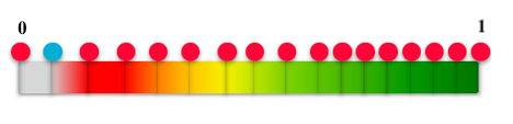
Green palette, the common NDVI palette - 1 (default)
-
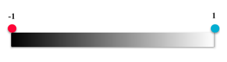
Technical palette, black & white, to set your colours - 2
-
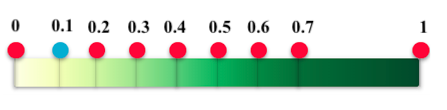
Contrast palette #1 - 3
-
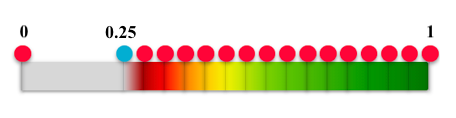
Contrast palette #2 - 4
To get an image of your polygon in other custom palettes, just add an additional parameter to the get URL:
paletteid — Palette ID (values correspond to the list above - 1, 2, 3, 4)
Example of API request:
http://api.agromonitoring.com/image/1.0/02059768a00/5ac22f004b1ae4000b5b97cf?appid=bb0664ed43c153aa072c760594d775a7&paletteid=1
Get tiles with your polygon in PNG format with "tile"
This API call is a part of the response of the Satellite Imagery Search API. You will receive a link to the tile layer for insert in the plugin or an application, if it supports, to display the tile layers. Tiles are provided in the following presets - True color, False color, NDVI, EVI, EVI2, NRI, DSWI, and NDWI.
In Step 1 of your polygon, the period of searching and your API key. The URL received in the response in the 'tile' (on step 1) insert into special plugins, for example Leaflet and OpenLayers, etc. Also you can use any other applications that support to display the tile layers.
-
znumber of zoom level -
xnumber of x tile coordinate -
ynumber of y tile coordinate
Example of API request for insert into special plugins:
http://api.agromonitoring.com/tile/1.0/{z}/{x}/{y}/00059768a00/5ac22f004b1ae4000b5b97cf?appid=bb0664ed43c153aa072c760594d775a7
Get metadata and statistics of your polygon with "stat"
This API call is a part of the response of the Satellite Imagery Search API. It is available only for NDVI, EVI, EVI2, NRI, DSWI, and NDWI indices.
In Step 1, specify the ID of your polygon, the period of searching, and your API key. The URL received in the response in the 'tile' (on step 1) inserts into special plugins, for example Leaflet and OpenLayers, etc. Also you can use any other applications that support to display the tile layers.
Example of API call:
http://api.agromonitoring.com/stats/1.0/02359768a00/5ac22f004b1ae4000b5b97cf?appid=bb0664ed43c153aa072c760594d775a7
Example of API response "stat" section:
{
"std":0.19696951630010479,
"p25":0.3090659340659341,
"num":57162,
"min":-0.2849250197316496,
"max":0.8658669574700109,
"median":0.45692992317131553,
"p75":0.6432460461498574,
"mean":0.47631485576814037
}
Parameters of response for a polygon:
stdThe standard deviation of the index
p25The first quartile value of the index
numThe number of pixels in the current polygon
minThe minimum value of the inde
maxThe maximum value of the index
medianThe median value of the index
p75The third quartile value of the index
meanThe average value of the index
Get your polygon in GeoTIFF format with "data"
This API call is a part of the response of the Satellite Imagery Search API. You can download your polygon in GeoTIFF format in the following presets - True color, False color, NDVI, EVI, EVI2, NRI, DSWI, and NDWI. The dataset depends on the type of preset.
In Step 1, specify the ID of your polygon, the period of searching, and your API key. In the API response, you will receive URLs to download your polygon in GeoTIFF format on different presets. You can use the following instrument for open downloaded file: Photoshop, QGIS, GRASS GIS, etc.
Example of API request (Download NDVI satellite image in GeoTIFF):
http://api.agromonitoring.com/data/1.0/02259768a00/5ac22f004b1ae4000b5b97cf?appid=bb0664ed43c153aa072c760594d775a7
Custom palette for NDVI images
We have 4 preset custom palettes for NDVI images, the most practical pallets for agricultural applications:
-
Green palette, the common NDVI palette (default)
-
Technical palette, black & white, to set your colours
-
Contrast palette #1
-
Contrast palette #2
To get an image of your polygon in other custom palettes, just add an additional parameter to the get URL on Step 2.
paletteid — Palette ID (values correspond to the list above - 1, 2, 3, 4)
Example of API request:
http://api.agromonitoring.com/image/1.0/02059768a00/5ac22f004b1ae4000b5b97cf?appid=bb0664ed43c153aa072c760594d775a7&paletteid=1
Default Palette:
paletteid=1Green palette, the common NDVI palette. Control points: (0, 0.1, 0.2, 0.3, 0.4, 0.5, 0.6, 0.7, 1)
Technical palette:
paletteid=2Black & white, to set your colours. Control points: (0, 1)
Contrast palette #1:
paletteid=3Control points: (0, 0.25, 0.3, 0.35, 0.4, 0.45, 0.5, 0.55, 0.6, 0.65, 0.7, 0.75, 0.8, 0.85, 0.9, 0.95, 1)
Contrast palette #2:
paletteid=4Control points: (0, 0.07, 0.15, 0.23, 0.3, 0.37, 0.45, 0.51, 0.58, 0.65, 0.7, 0.75, 0.8, 0.85, 0.9, 0.95, 1)